Flight shapesPiper PA-28 CherokeeReception source: ADS-B, ICAO address
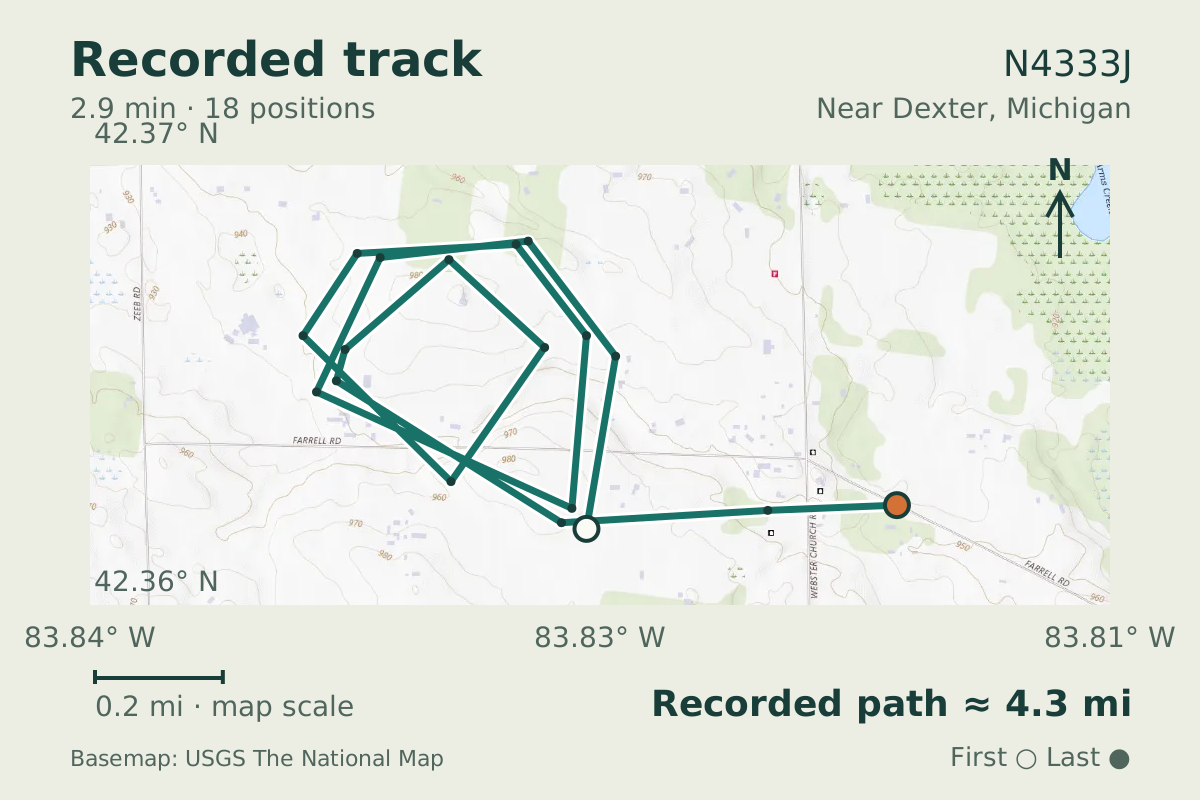
Piper Cherokee N4333J traces two loops while losing altitude
The looping descent shed 2,300 feet. The aircraft database lists the aircraft as a Piper PA-28 Cherokee.
- Replay time · UTC
- —
- Last saved report · UTC
- —
- Recorded path
- —
- Reported ground speed
- —
- Archived altitude
- —
The dot moves between saved positions. Readings are from the last saved report. Recorded path is approximate and excludes gaps. Distances use nautical miles (nmi); speed uses knots (nmi per hour).

Two closed loops accompanied a 2,300-foot descent by N4333J on October 26, 2026. The looping segment took 176 seconds, with pressure altitude falling from 4,900 feet to 2,600 feet as the aircraft circled.
The flight was near Dexter, Michigan. This is a 59-year-old airframe, with a 1967 build year recorded in the aircraft database. The track does not establish why it flew those loops.
The Cherokee design also provided the basis for the Piper Cherokee Six, introduced in 1966 with a wider cabin and six seats. That was a development of the family; the aircraft in this observation is listed as a PA-28 Cherokee.
About the Piper PA-28 Cherokee
- Piper introduced the PA28 Cherokee in 1961.
- The Cherokee was the basis for the Piper Cherokee Six, introduced in 1966 with a wider cabin and six seats.
Recorded data for N4333J
| Observed | to |
|---|---|
| Event type | Flight patterns |
| Recorded source | ADS-B, ICAO address |
| Post date | |
| Last revised |
| Aircraft type | PIPER PA-28-140/150/160/180 |
|---|---|
| Type designator | P28A |
| Tail number (registration) | N4333J |
| Callsign | N4333J |
| ICAO address | A5310D |
Measurements
Displayed measurements may be rounded.
- Ground speed
- 108.1 kn
- speed over the ground; wind adds to or subtracts from it
- Pressure altitude
- 2,600 ft
- pressure altitude, the figure pilots and controllers use
All measurements and the evidence record
| Ground speed | 108.1 kn |
|---|---|
| Pressure altitude | 2,600 ft |
| Geometric altitude | 2,900 ft |
| Geometric-altitude vertical rate | -448 ft/min |
| Navigation integrity category | 9 |
| Navigation accuracy category | 10 |
| Transponder code | 1200 |
| Episode start altitude | 4,900 ft |
|---|---|
| Episode end altitude | 2,600 ft |
| Episode duration | 176 s |
| Telemetry samples | 18 samples |
| Observed altitude change | -2,300 ft |
| Closed loops | 2 loops |
Evidence version: 02af5f3c2837bde4.
Record details
Public event ID: 2fc242d5-7ae1-48.
Record revision: 2.