Flight shapesCessna 172 SkyhawkReception source: ADS-B, ICAO address
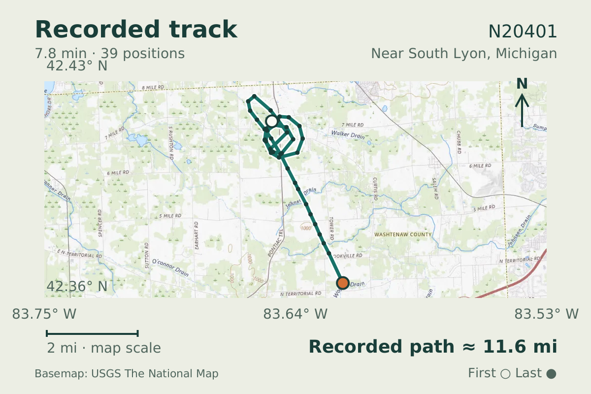
Cessna 172 Skyhawk N20401 draws a closed loop during descent
Callsign CXK470 accompanied the 22 November 2026 observation, with a descending section lasting 470.7 seconds.
- Replay time · UTC
- —
- Last saved report · UTC
- —
- Recorded path
- —
- Reported ground speed
- —
- Archived altitude
- —
The dot moves between saved positions. Readings are from the last saved report. Recorded path is approximate and excludes gaps. Distances use nautical miles (nmi); speed uses knots (nmi per hour).

A closed loop marks the descending section of N20401's track near South Lyon, Michigan. Across that section, pressure altitude dropped from 5,200 feet to about 2,400 feet. The track covered 10.05 nautical miles, with 39 samples describing the section containing the loop.
A descending spiral is a standard maneuver, practiced to lose height over one spot. The shape alone does not establish why this aircraft flew the pattern. For the aircraft making the descending turn, the aircraft database entry gives the full type name as Cessna 172 Skyhawk and the type code as C172.
About the Cessna 172 Skyhawk
- The Cessna 172 Skyhawk first flew on June 12, 1955.
- The Cessna 172 Skyhawk is a piston aircraft with one engine and a high wing.
- The Cessna 172 Skyhawk was introduced as a successor to the Cessna 170.
- The Cessna 172 Skyhawk has tricycle landing gear rather than a tailwheel.
Recorded data for N20401
| Observed | to |
|---|---|
| Event type | Flight patterns |
| Recorded source | ADS-B, ICAO address |
| Post date | |
| Last revised |
| Aircraft type | CESSNA 172 Skyhawk |
|---|---|
| Type designator | C172 |
| Tail number (registration) | N20401 |
| Callsign | CXK470 |
| ICAO address | A1A351 |
Measurements
Displayed measurements may be rounded.
- Ground speed
- 75.6 kn
- speed over the ground; wind adds to or subtracts from it
- Pressure altitude
- 2,375 ft
- pressure altitude, the figure pilots and controllers use
All measurements and the evidence record
| Ground speed | 75.6 kn |
|---|---|
| Pressure altitude | 2,375 ft |
| Geometric altitude | 2,275 ft |
| Pressure-altitude vertical rate | 64 ft/min |
| Navigation integrity category | 9 |
| Navigation accuracy category | 10 |
| Transponder code | 1200 |
| Episode start altitude | 5,200 ft |
|---|---|
| Episode end altitude | 2,375 ft |
| Episode duration | 471 s |
| Telemetry samples | 39 samples |
| Observed altitude change | -2,825 ft |
| Closed loops | 1 loops |
Evidence version: 76bae7c431f7bba1.
Record details
Public event ID: d1de6a49-5c2d-4a.
Record revision: 2.