Flight shapesAirbus Helicopters AS365 DauphinReception source: ADS-B, ICAO address
Plane Alert DB lists Dauphin helicopter in Coastguard category
The aircraft database records an Airbus Helicopters AS365 Dauphin for the November 5, 2026 observation.
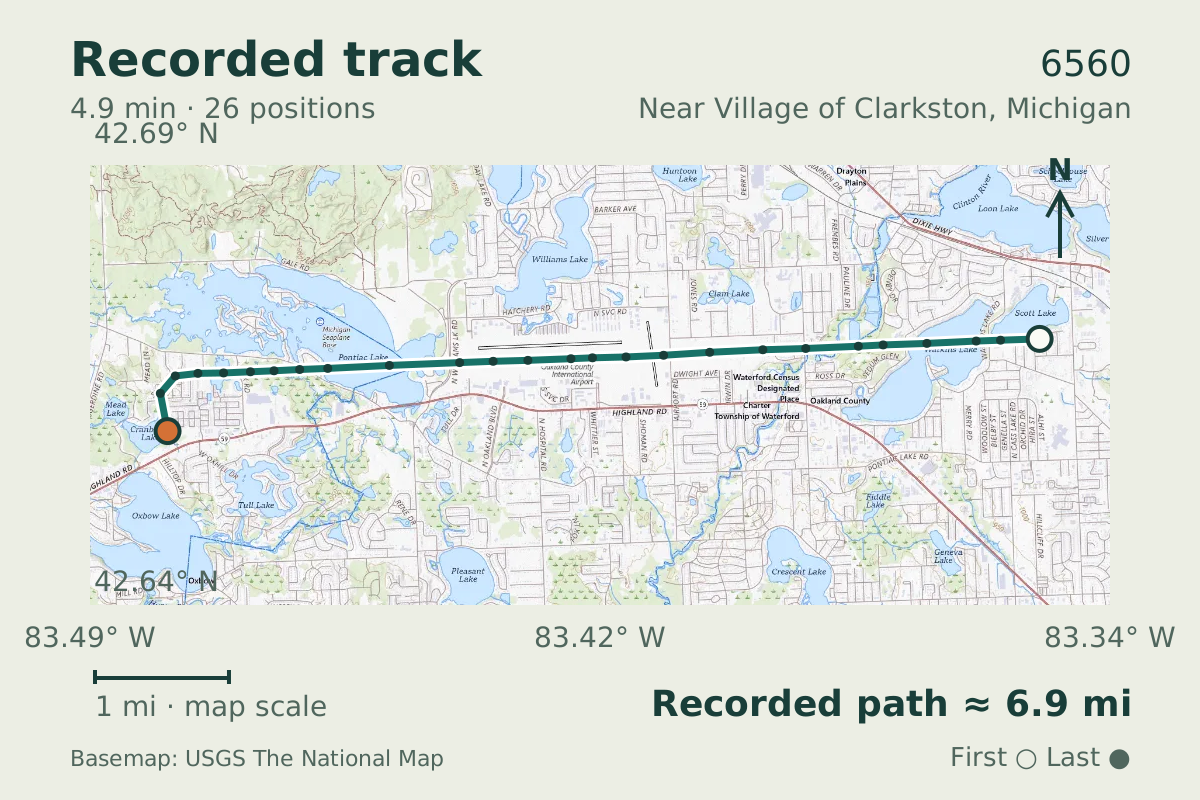
- Replay time · UTC
- —
- Last saved report · UTC
- —
- Recorded path
- —
- Reported ground speed
- —
- Archived altitude
- —
The dot moves between saved positions. Readings are from the last saved report. Recorded path is approximate and excludes gaps. Distances use nautical miles (nmi); speed uses knots (nmi per hour).
Near Village of Clarkston, Michigan, helicopter 6560 reported a ground speed of 64 knots. Its transmitted callsign was C6560.
Plane Alert DB, a community watchlist used by spotters, associates the aircraft with the United States Coast Guard. The entry does not establish who operated this flight. It describes the helicopter as a Eurocopter MH-65C Dolphin and places it in the Coastguard category and government group. The entry also carries the tags "Maritime Patrol", "Search And Rescue", and "Mae West", labels attached to the aircraft on the list.
Why this was our weekly pick
Ground speed of 63.9 kn and pressure altitude of 3,175 ft describe motion and a pressure reference, but cannot establish a go-around without the approach-to-climb sequence.
What a possible go-around means
About this kind of event
A go-around discontinues an approach to landing while the aircraft remains airborne. The FAA describes it as a routine maneuver that returns the aircraft to an altitude and configuration suitable for another approach. Its helicopter handbook describes increasing power, establishing a climb attitude, and maintaining climb speed after the decision to discontinue the landing. The label possible go-around therefore concerns a change in the progress of an approach. The supplied readings alone do not document that sequence or confirm that a landing approach was abandoned. [1] [2]
What the readings report
About this kind of event
The reported ground speed is 63.9 kn, and the pressure altitude is 3,175 ft. The FAA defines ground speed relative to the earth’s surface. Its ADS-B guidance distinguishes that horizontal motion from airspeed, which comes from other aircraft sensors. The guidance also identifies transmitted barometric altitude as pressure altitude referenced to a standard altimeter setting. It distinguishes this from satellite-derived geometric altitude. Consequently, the supplied altitude should not be read as a direct measurement of clearance above the landing surface. [3] [4]
What makes this observation worth examining
About this kind of event
The useful distinction here is between a maneuver label and the quantities reported alongside it. Neither the FAA’s general description nor its helicopter go-around guidance defines the maneuver by a particular ground speed or pressure altitude. These readings therefore provide no supported basis for calling this an unusually fast or high go-around. Assessing the possible label would require evidence of the approach being discontinued and a climb being established. The supplied snapshot leaves that transition unconfirmed. [1] [2] [3]
What remains uncertain
- The aircraft type comes from a database match. These sources describe this kind of event and the type in general; they do not independently identify this airframe or establish its mission, occupants, or reason for flying.
- Research was gathered after the observation. Historical aircraft metadata may have changed; the recorded reports remain separate from the background above.
Research sources
- Go-Arounds Explained — Federal Aviation Administration. Background on this kind of event; not this airframe or flight. Accessed .
- Rotorcraft Flying Handbook: Normal Approach to the Surface and Go-Around — Federal Aviation Administration. Background on this kind of event; not this airframe or flight. Accessed .
- Frequently Asked Questions — Federal Aviation Administration. Background on this kind of event; not this airframe or flight. Accessed .
- Pilot/Controller Glossary: G — Federal Aviation Administration. Background on this kind of event; not this airframe or flight. Accessed .
Recorded data for 6560
| Observed | to |
|---|---|
| Event type | Flight patterns |
| Recorded source | ADS-B, ICAO address |
| Post date | |
| Last revised |
| Aircraft type | Eurocopter MH-65D Dolphin |
|---|---|
| Type designator | AS65 |
| Tail number (registration) | 6560 |
| Callsign | C6560 |
| ICAO address | AE2692 |
Measurements
Displayed measurements may be rounded.
- Ground speed
- 63.9 kn
- speed over the ground; wind adds to or subtracts from it
- Pressure altitude
- 3,175 ft
- pressure altitude, the figure pilots and controllers use
All measurements and the evidence record
| Ground speed | 63.9 kn |
|---|---|
| Pressure altitude | 3,175 ft |
| Geometric altitude | 2,900 ft |
| Geometric-altitude vertical rate | 0 ft/min |
| Navigation integrity category | 10 |
| Navigation accuracy category | 11 |
| Transponder code | 5167 |
| Episode duration | 294 s |
|---|---|
| Telemetry samples | 26 samples |
| Altitude excursion | 1,550 ft |
Evidence version: 05fd7d3f6f41c369.
| Source | Plane Alert DB |
|---|---|
| Association | United States Coast Guard |
| List category | Coastguard |
| Tags | Maritime Patrol, Search And Rescue, Mae West |
| Group | government |
| Listed aircraft | Eurocopter MH-65C Dolphin |
| Entry link | https://www.uscg.mil/ |
| Category | Curated aircraft entry |
| Pinned source version | 6f7a19044a8dc9ed |
| Attribution | Aircraft association/category: Plane Alert DB / SDR-Enthusiasts and contributors. |
| Licences | Open Database License 1.0; Database Contents License 1.0 |
| Scope | Source association only; not verified current ownership, operator, historical association, or presence of any person aboard. |
Record details
Public event ID: 9a6a5a78-ba0e-43.
Record revision: 4.